Land Use Classification of Al-Rifai City Manually and Using Google Earth
DOI:
https://doi.org/10.54174/pj71ev55Keywords:
Land use, Image, Google Earth, Al-Rifai, ClassificationAbstract
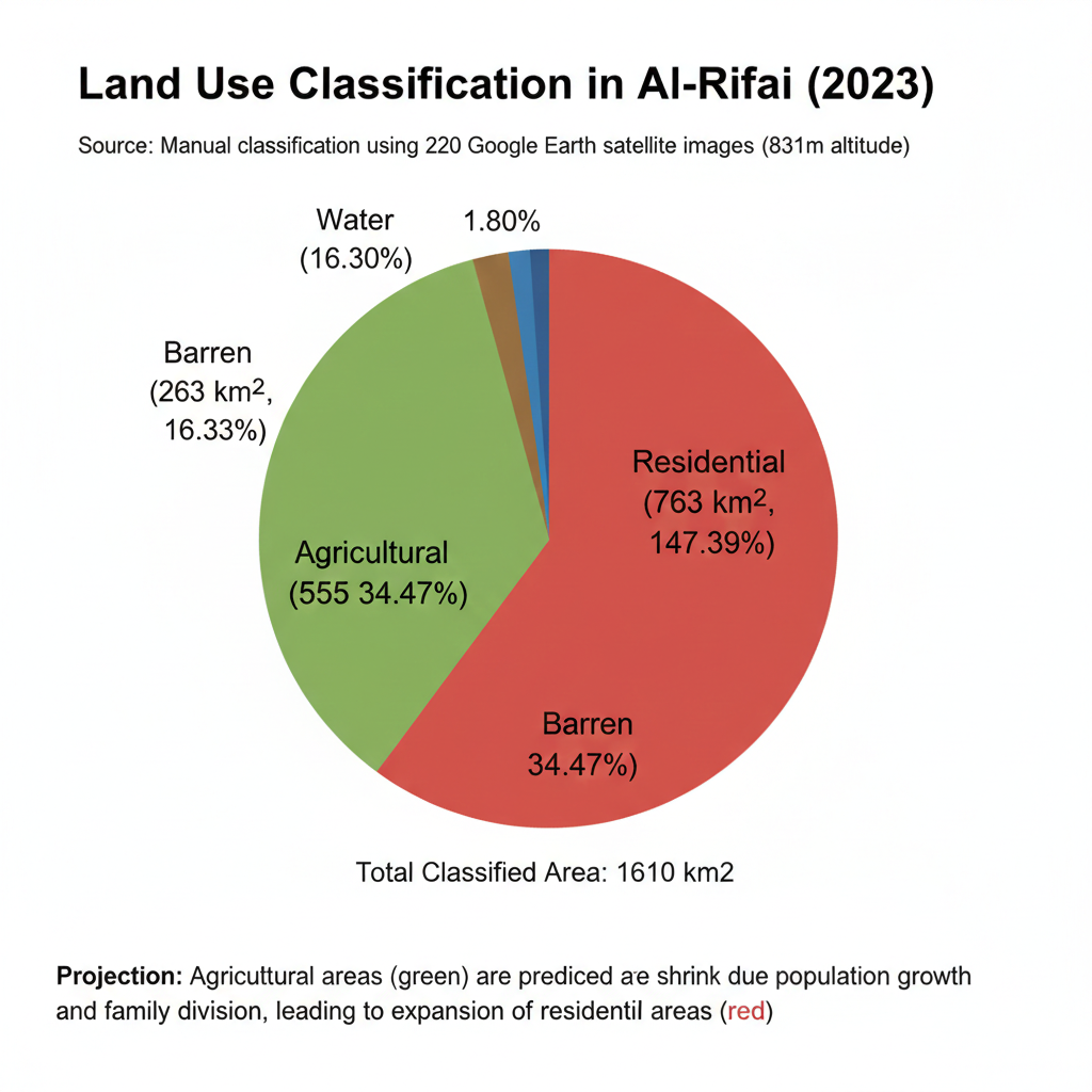
The research dealt with a manual classification of land uses in Al-Rifai area using (220) satellite images taken from Google Earth and captured at an altitude of 831 m. Each image was divided into squares with dimensions of 2 cm x 2 cm, which equals to 0.2 km2 as an actual area. Red color represents to residential (urban) lands, green color represents agricultural lands, and brown color represents barren lands, while water areas were colored blue. Through the manual classification of land uses in the areas located within the administrative boundaries of Al-Rifai city, with a total area of 1610 km2, it became clear that the areas of residential areas were approximately (763) km2 with a percentage of (47.39%), agricultural areas were approximately (555) km2 with a percentage of (34.47%), barren areas were approximately (263) km2 with a percentage of (16.33%), and water areas were approximately (29) km2 which equals about (1.80%). Using the drawn color map, it can be predicted that the agricultural areas (green), located in scattered patches between residential areas (red), could shrink due to population growth and family division.
Downloads
References
Abu Nuqta, F. and Habib, H. S. (2010). Soil Survey and Classification. Damascus, Damascus: Publications Faculty of Agriculture: Damascus University, 2010.
Al-Akeedi, W. K. H. (1990). Soil Management and Land Use.
Al-Humeiri, M. A. J. (2019). The use of remote sensing and GIS techniques in mapping vegetation changes between two seasones (Babil governorate model). Journal of Geographical Research ( 29): 243-270.
Al-Yaqoubi, J. S. Y. (2010) Classification of land use and land cover in Al-Rashidiya district using remote sensing and geographic information systems. Faculty of Arts Journal(94): 214-242.
Chlaib, H. K., Beedeh, R. S., Jabbar, N. S. and Hurayjah, T. S. (2019). Vertical and horizontal variations in the soil salinity content for selected soil samples in Al-Refaee city, The-Qar, Iraq. Muthanna journal of Agriculture Scienc. 7(2): 159-175. https://doi.org/10.18081/MJAS/2019-7/159-175
Hannad, A. A. A. (2016). Use of geographic information systems and remote investment in future tourist planning and direction for Gaza Governorates. Journal of the Social Sciences 44 ( 4): 233-272. https://doi.org/10.34120/0080-044-004-006
Saleem, J. Y. (2018). Using remote sensing and geographic information systems to the classification of agricultural land uses and land cover in Al-sad Al-Adhim sub district – Iraq. Alustath Journal for Human and Social Sciences. 225 (2): 245-273. https://doi.org/10.36473/ujhss.v225i2.151
Downloads
Published
Issue
Section
License
Copyright (c) 2025 Hussein Chlaib, Fatmah Adil Mohammed, Najem Abd Abd Yasir, Hakeem R. Zachi

This work is licensed under a Creative Commons Attribution-NonCommercial-ShareAlike 4.0 International License.